
Featured Documents

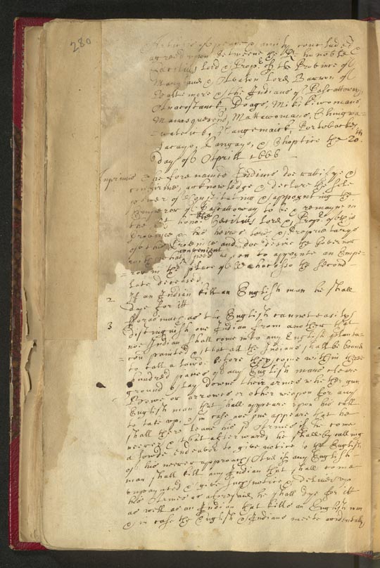
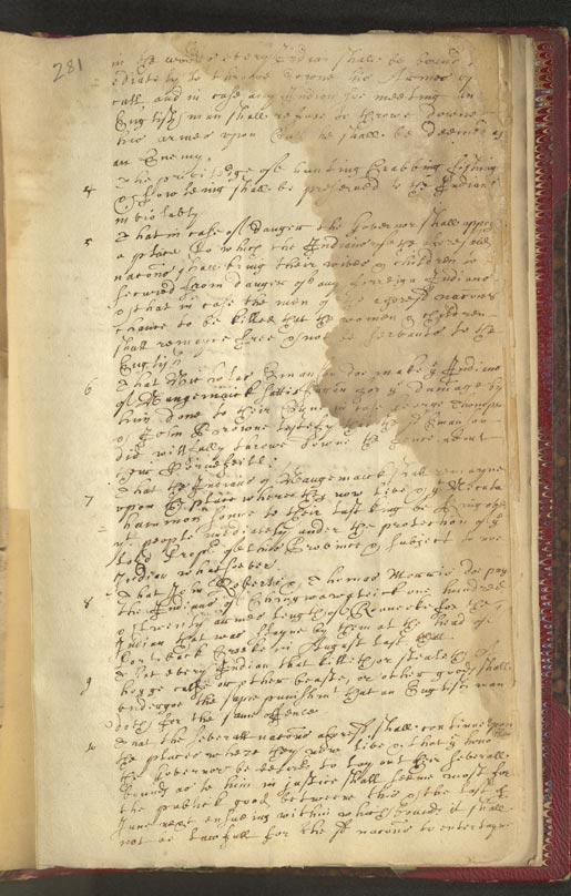
April 1666 Treaty of Maryland with multiple Nations and Reparation
Citation: S977-2 (Pages 280-283)
Articles of Peace and Amity, dated 20
April 1666, between the Lord Baron of
Baltimore and the Province of Maryland
and the Pascattaway, Anacostanck, Doags,
Mikikiwomans, Manasquesend, Mattawomans,
Chingwawateick, Hangemaick, Portobackes,
Sacayo, Panyayo, and Choptico Nations,
regarding the Rules and Restrictions
concerning Colonial/Indigenous Relations
and Reparations to the Chingwawater and
Nangemaick Nations for Colonists'
Crimes. Signed by: Amehoick for the
Matchecomico and Sacayo, Choticke
Councellor of Chingwawateick and
Pangayo, Unawcawtanim for Mattawoman,
Necutahamon King of Nangemy, and
Mawnawzimo for Nangemy.
|

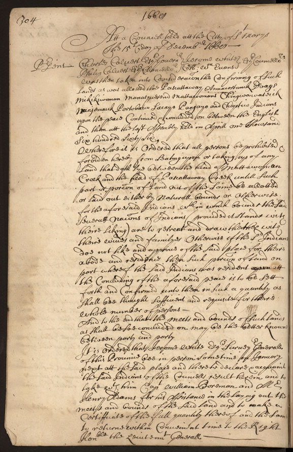
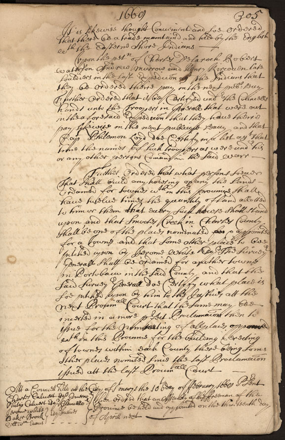
December 1669 Land and Trade Agreements between Maryland and multiple Indigenous Nations
Citation: S1071-5 (pages 304-305)
Declared on 15 December 1669 at the City
of St. Marys, that the Lands Allocated
to the Pascattaway, Annacostanck, Doags,
Mikikiwoman, Manasquesend, Mattawomans,
Chingwawateick, Nanjemauk, Portobacco,
Sacayo, Pangayo, and Chaptico Indians
belong explicitly to those Tribes, and
no Colonists may settle there; however,
Trade must be Maintained between the
English and the Eastern Shore
Indigenous.
|
| Back to Top |

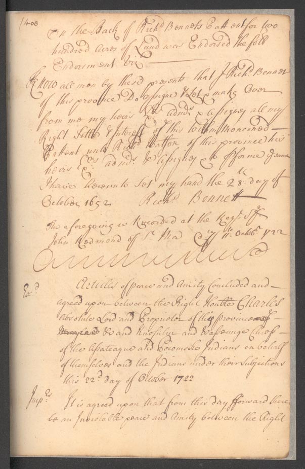
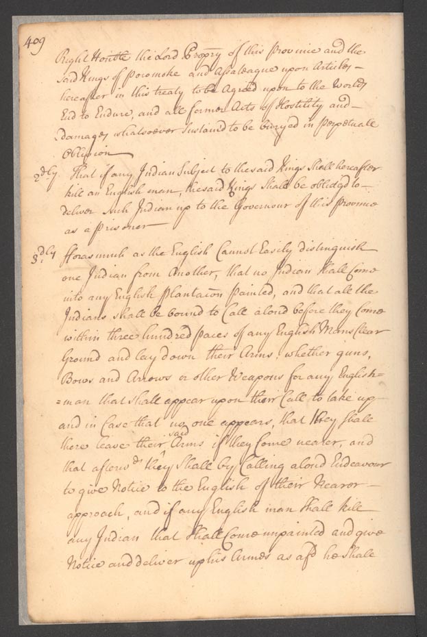
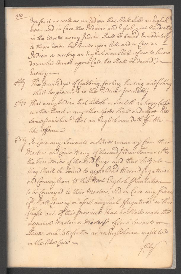
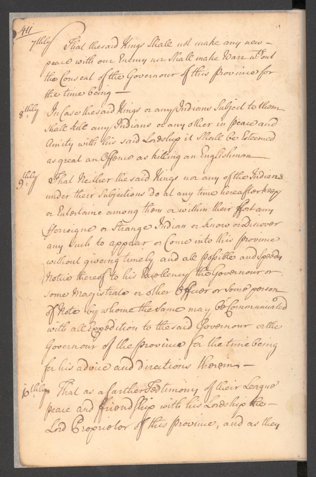
Treaty between Maryland and the Assateague and Pocomoke Nations
Citation: S552-12 (page 408-412)
Articles of Peace and Amity, dated 22
October 1722, between the Province of
Maryland and Knosulin, alias Mr. Walker,
and Wassennge, alias Daniel, Chiefs of
the Assateague and Pocomoke Nations
respectively, with specific Demands for
Yearly Tribute for English Protections.
Signed by: Knosulin, King of the
Assateague Indians and Wassennge, King
of the Pocomoke Indians.
|
| Back to Top |
December 1669 Land and Trade Agreements between Maryland and multiple Indigenous Nations
Citation: S1071-5 (pages 304-305)
Declared on 15 December 1669 at the City
of St. Marys, that the Lands Allocated
to the Pascattaway, Annacostanck, Doags,
Mikikiwoman, Manasquesend, Mattawomans,
Chingwawateick, Nanjemauk, Portobacco,
Sacayo, Pangayo, and Chaptico Indians
belong explicitly to those Tribes, and
no Colonists may settle there; however,
Trade must be Maintained between the
English and the Eastern Shore
Indigenous.
|
| Back to Top |

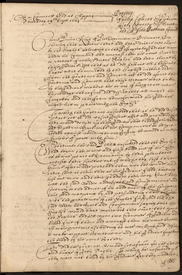
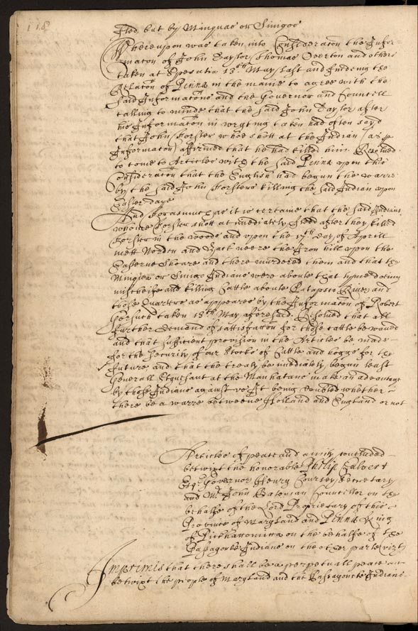
Treaty between Maryland and the Passayoncke Indians
Citation: S1071-5 (pages 117-119)
Articles of Peace and Amity, dated 19
September 1661, between the Province of
Maryland and Pinna, King of
Pickhattomitta, on behalf of the
Passayonke Nation in Response to Violent
Interactions between Indigenous Peoples
(Passayonke, Miniqua, or Sinigo) and
colonists. Signed by: Pinna.
|
| Back to Top |
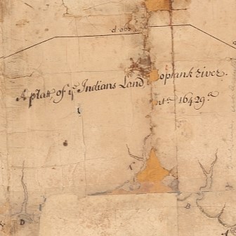
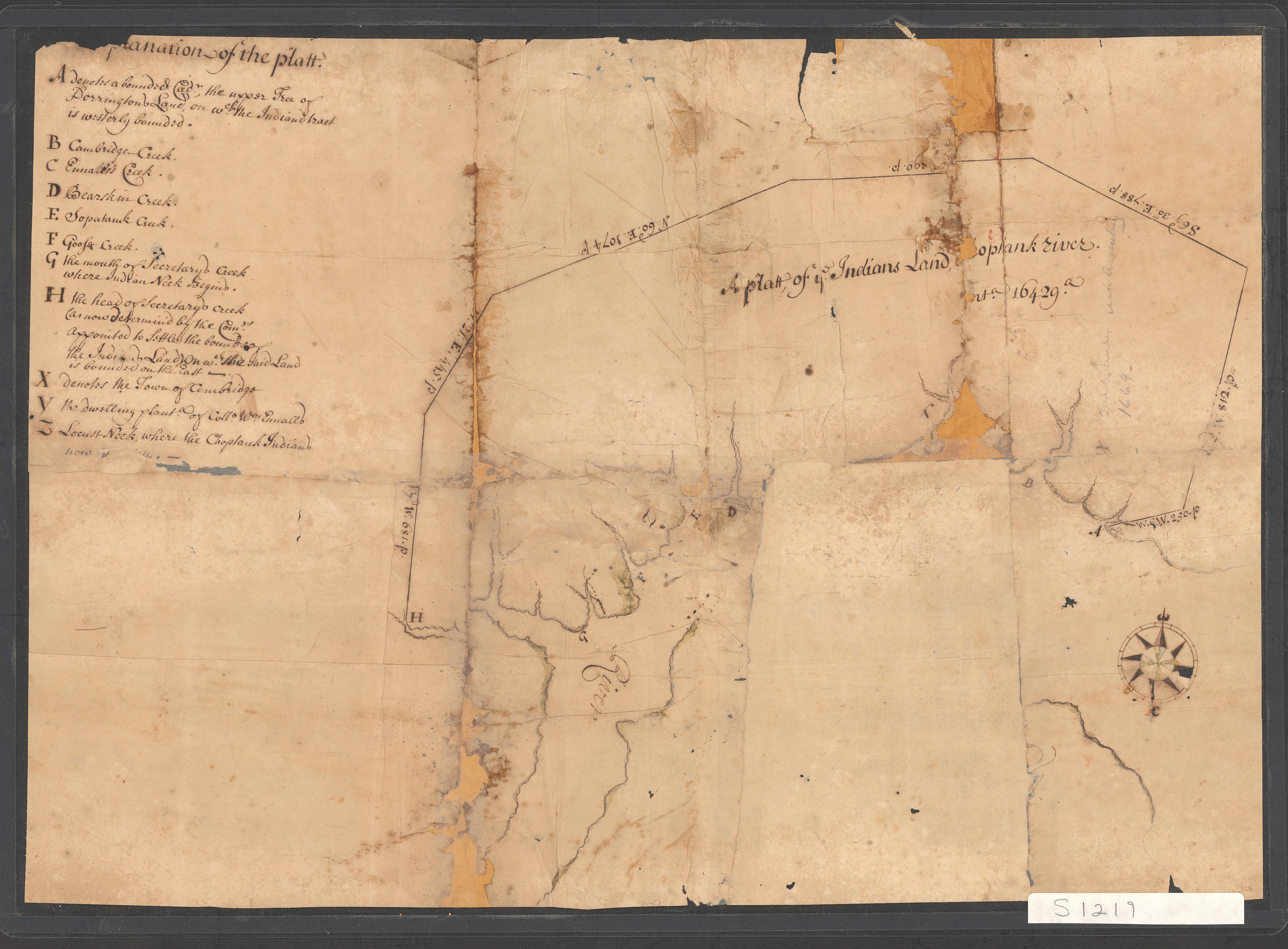
The Plat of Indians Land on the Choptank River
Citation: S1219-1083-027
A surveyor drew this plat of 16,429
acres in Dorchester County to denote
what the English Colonists thought of as
land set aside for the Choptank Indians.
This fragmented plat is one page from a
Land Office Certificate of survey file
documenting land described as “Nanticoke
Mannor, Vienna Town, Nanticoke Indian
Lands.” A certificate of survey is an
official description of a plot of land.
The Land Office issued warrants of
survey to the county surveyor who then
generated certificates of survey as part
of the land patent process. This plat is
unpatented, meaning a land patent was
not issued.
|
| Back to Top |

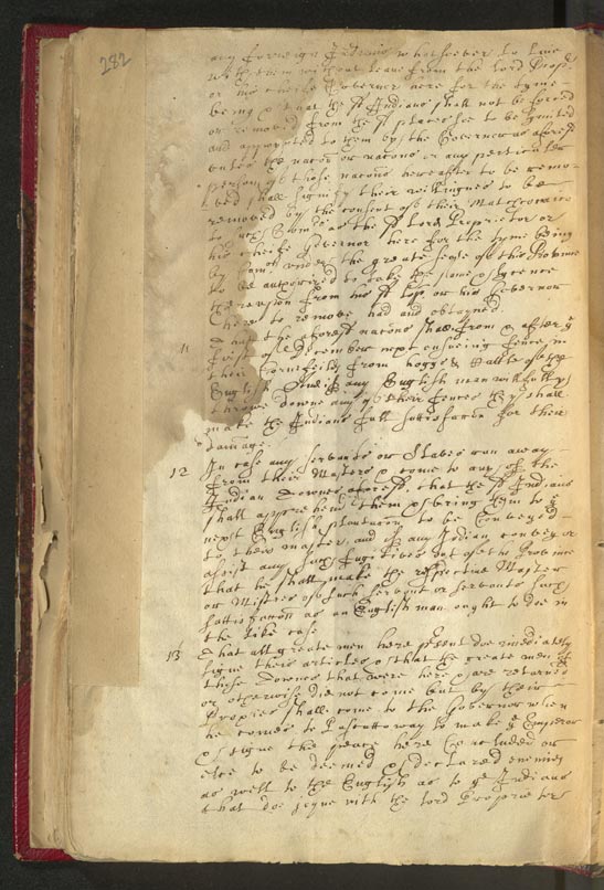
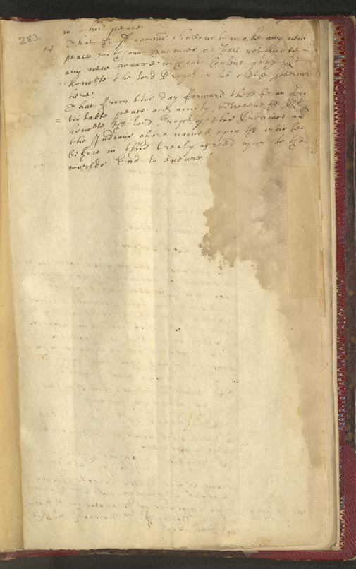
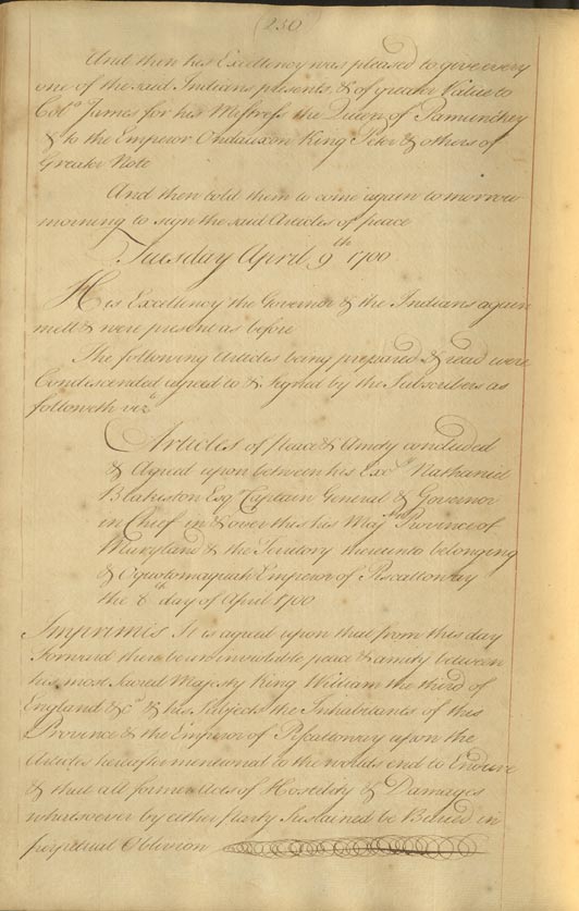
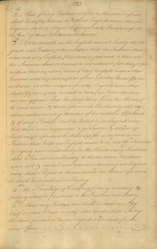
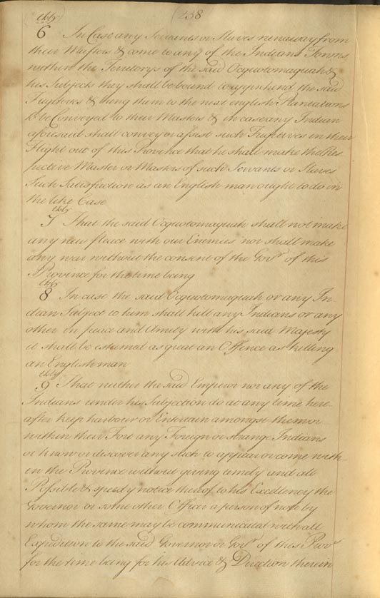
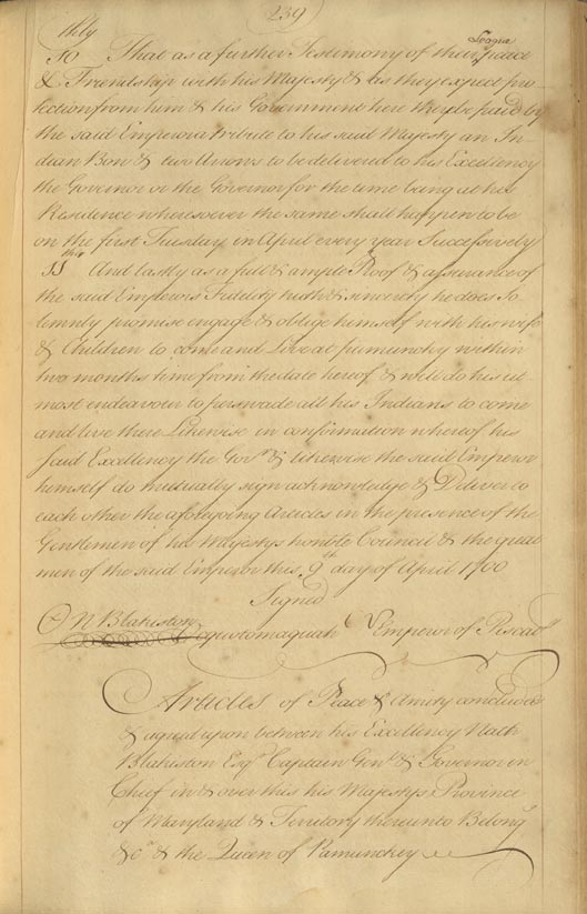
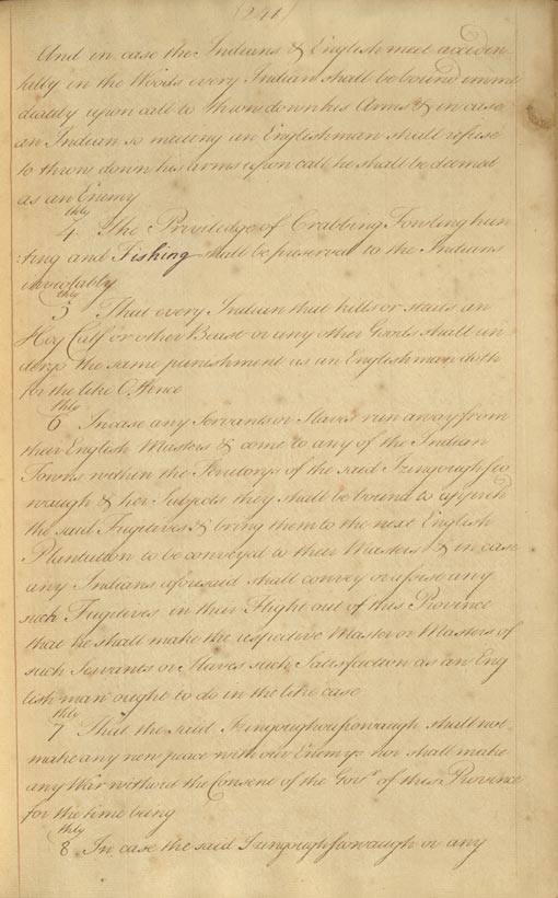
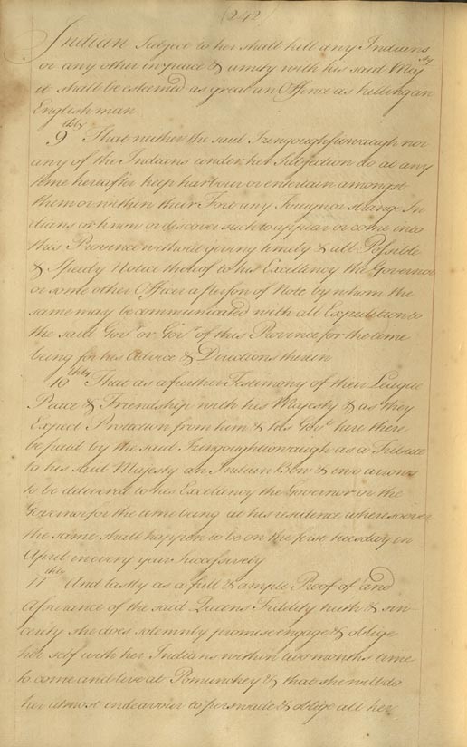
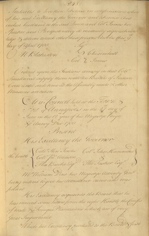
Treaty between Maryland and the Piscattaway and Pamunckey Nations and Relocation of both Nations to Pomunckey
Citation: S1071-13 (pages 236-243)
Articles of Peace and Amity, dated 9
April 1700, between the Province of
Maryland and Oquotomaquah, the Emperor
of Piscattaway, and the Province of
Maryland and Izingoughsiowaugh, the
Queen of Pamunckey, with Specific
Demands for Yearly Tributes for English
Protections and the Relocation of both
Nations to Pomunckey.
|
| Back to Top |
April 1666 Treaty of Maryland with multiple Nations and Reparation
Citation: S977-2 (Pages 280-283)
Articles of Peace and Amity, dated 20
April 1666, between the Lord Baron of
Baltimore and the Province of Maryland
and the Pascattaway, Anacostanck, Doags,
Mikikiwomans, Manasquesend, Mattawomans,
Chingwawateick, Hangemaick, Portobackes,
Sacayo, Panyayo, and Choptico Nations,
regarding the Rules and Restrictions
concerning Colonial/Indigenous Relations
and Reparations to the Chingwawater and
Nangemaick Nations for Colonists'
Crimes. Signed by: Amehoick for the
Matchecomico and Sacayo, Choticke
Councellor of Chingwawateick and
Pangayo, Unawcawtanim for Mattawoman,
Necutahamon King of Nangemy, and
Mawnawzimo for Nangemy.
|
December 1669 Land and Trade Agreements between Maryland and multiple Indigenous Nations
Citation: S1071-5 (pages 304-305)
Declared on 15 December 1669 at the City
of St. Marys, that the Lands Allocated
to the Pascattaway, Annacostanck, Doags,
Mikikiwoman, Manasquesend, Mattawomans,
Chingwawateick, Nanjemauk, Portobacco,
Sacayo, Pangayo, and Chaptico Indians
belong explicitly to those Tribes, and
no Colonists may settle there; however,
Trade must be Maintained between the
English and the Eastern Shore
Indigenous.
|
Treaty between Maryland and the Piscattaway and Pamunckey Nations and Relocation of both Nations to Pomunckey
Citation: S1071-13 (pages 236-243)
Articles of Peace and Amity, dated 9
April 1700, between the Province of
Maryland and Oquotomaquah, the Emperor
of Piscattaway, and the Province of
Maryland and Izingoughsiowaugh, the
Queen of Pamunckey, with Specific
Demands for Yearly Tributes for English
Protections and the Relocation of both
Nations to Pomunckey.
|

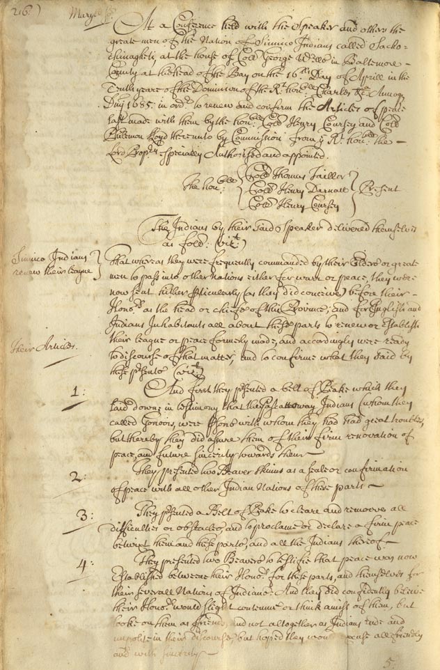
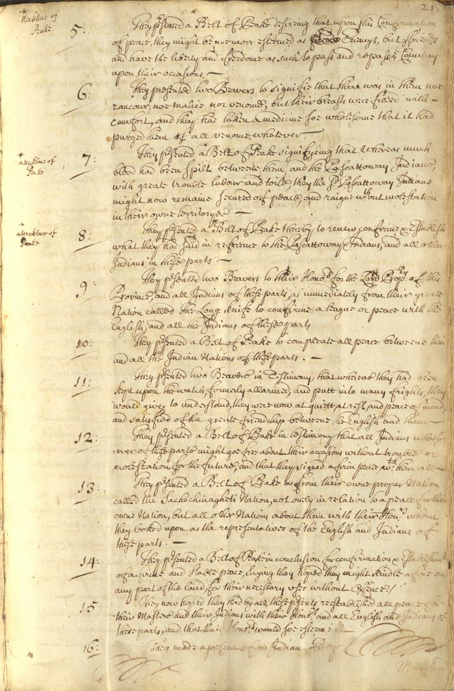
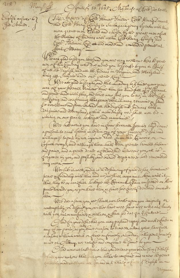
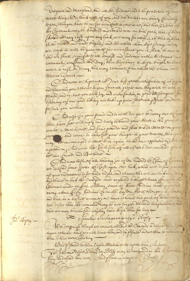
Renewal of Peace Treaty with Sinnico and Pascattaway Nations
Citation: S1071-7 (pages 216-219)
Exchange of Gifts and a Renewal of Peace
between the Sinnico (called
Sachochinagheti) and Pascattaway Nations
and the English, dated 16 April 1685, in
Baltimore County.
|

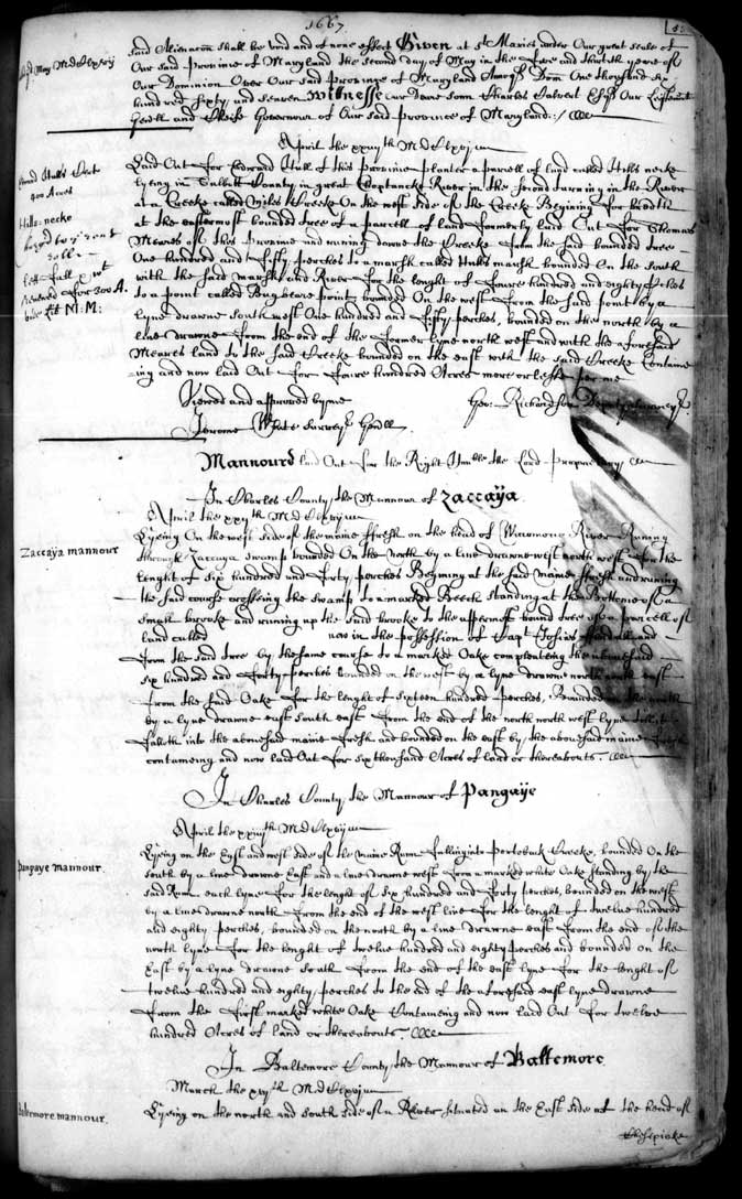
Land Patent for Zaccaya and Pangaye's Manors
Citation: SM215-7
Specific Locations of Zaccaya and
Pangaye's Mannors along Wiccomocco River
and Portobacke Creek respectively, as
determined in Late April, 1667 for the
Possession of the Lord Proprietary.
|
| Back to Top |
Treaty between Maryland and the Assateague and Pocomoke Nations
Citation: S552-12 (page 408-412)
Articles of Peace and Amity, dated 22
October 1722, between the Province of
Maryland and Knosulin, alias Mr. Walker,
and Wassennge, alias Daniel, Chiefs of
the Assateague and Pocomoke Nations
respectively, with specific Demands for
Yearly Tribute for English Protections.
Signed by: Knosulin, King of the
Assateague Indians and Wassennge, King
of the Pocomoke Indians.
|
| Back to Top |
Renewal of Peace Treaty with Sinnico and Pascattaway Nations
Citation: S1071-7 (pages 216-219)
Exchange of Gifts and a Renewal of Peace
between the Sinnico (called
Sachochinagheti) and Pascattaway Nations
and the English, dated 16 April 1685, in
Baltimore County.
|
| Back to Top |

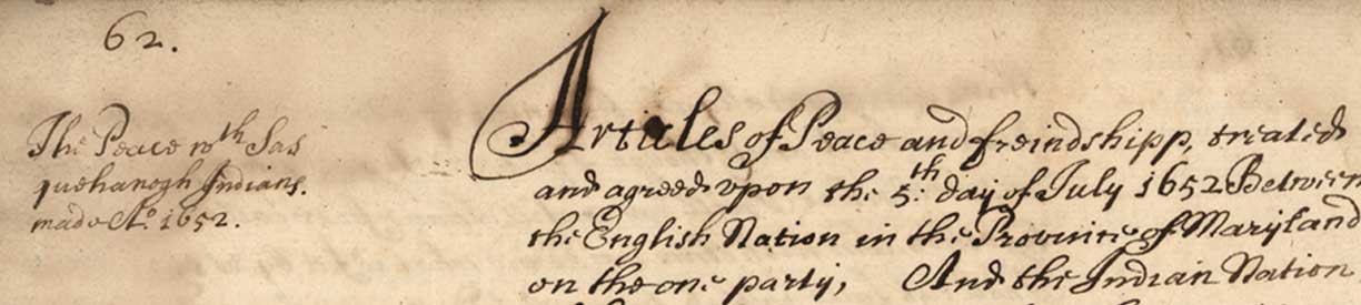
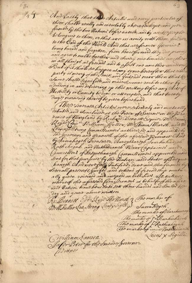
Treaty between Maryland and the Sasquesahanogh Nation
Citation: S1071-5 (pages 62-63)
Articles of Peace and Friendship, dated
5 July 1652, between the Province of
Maryland and the Sasquesahanogh Nation
defining the Relationship between the
Two Parties, while also specifically
detailing English Land Claims to Land in
and around the Chessapeake Bay. Signed
by: Sawahegeh, Treasurer, and War
Captains and Councellors Aurotaurogh,
Scarhuhadih, Ruthcuhogah, and
Wathetdianeh.
|

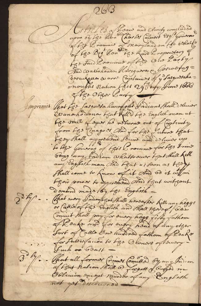
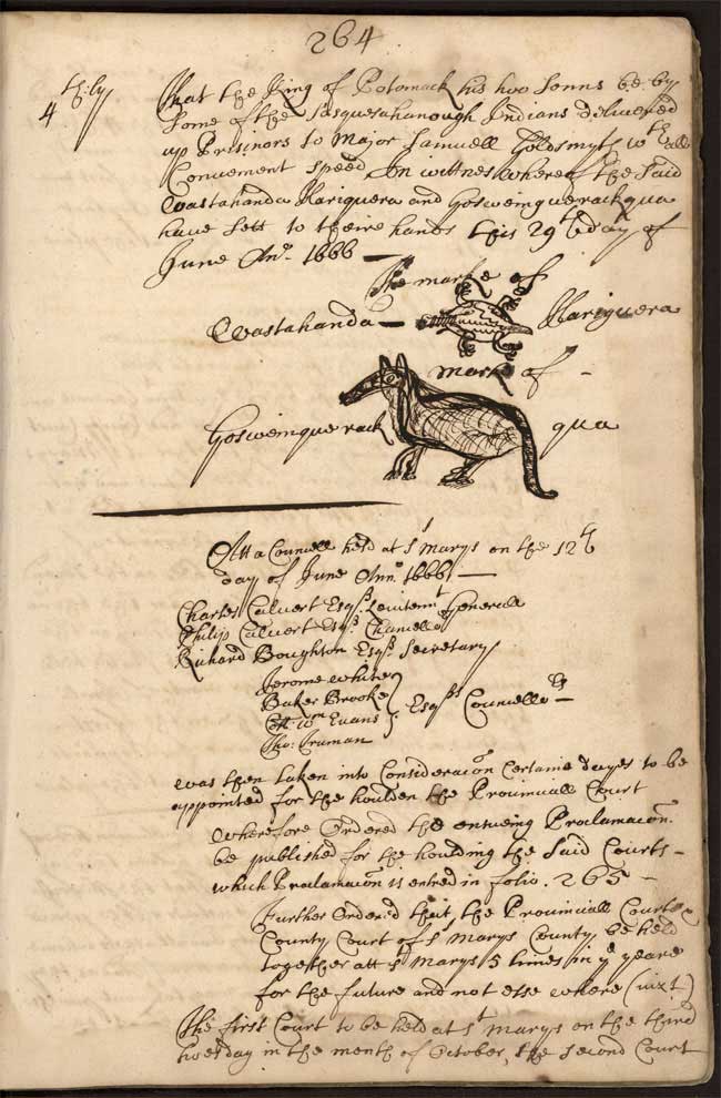
June 1666 Treaty with the Sasquesahanogh Nation and Reparations
Citation: S1071-5 (pages 263-264)
Articles of Peace and Amity, dated 29
June 1666, between the Province of
Maryland and Wastahanda Hariguera and
Gosweinquerack qua, War Captains of the
Sasquesahanough Nation in Response to
the Deaths of Englishmen in Baltimore
County by one Wanahedana of the
Sasquesahanoughs; Demand for the
Deliverance of the Two Sons of the King
of Potomack to Major Samuell Goldsymth
as Prisoners as Part of Reparations.
Signed by Wastahanda Hariguera and
Gosweinquerack qua with Pictographic
Signatures.
|
| Back to Top |
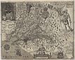
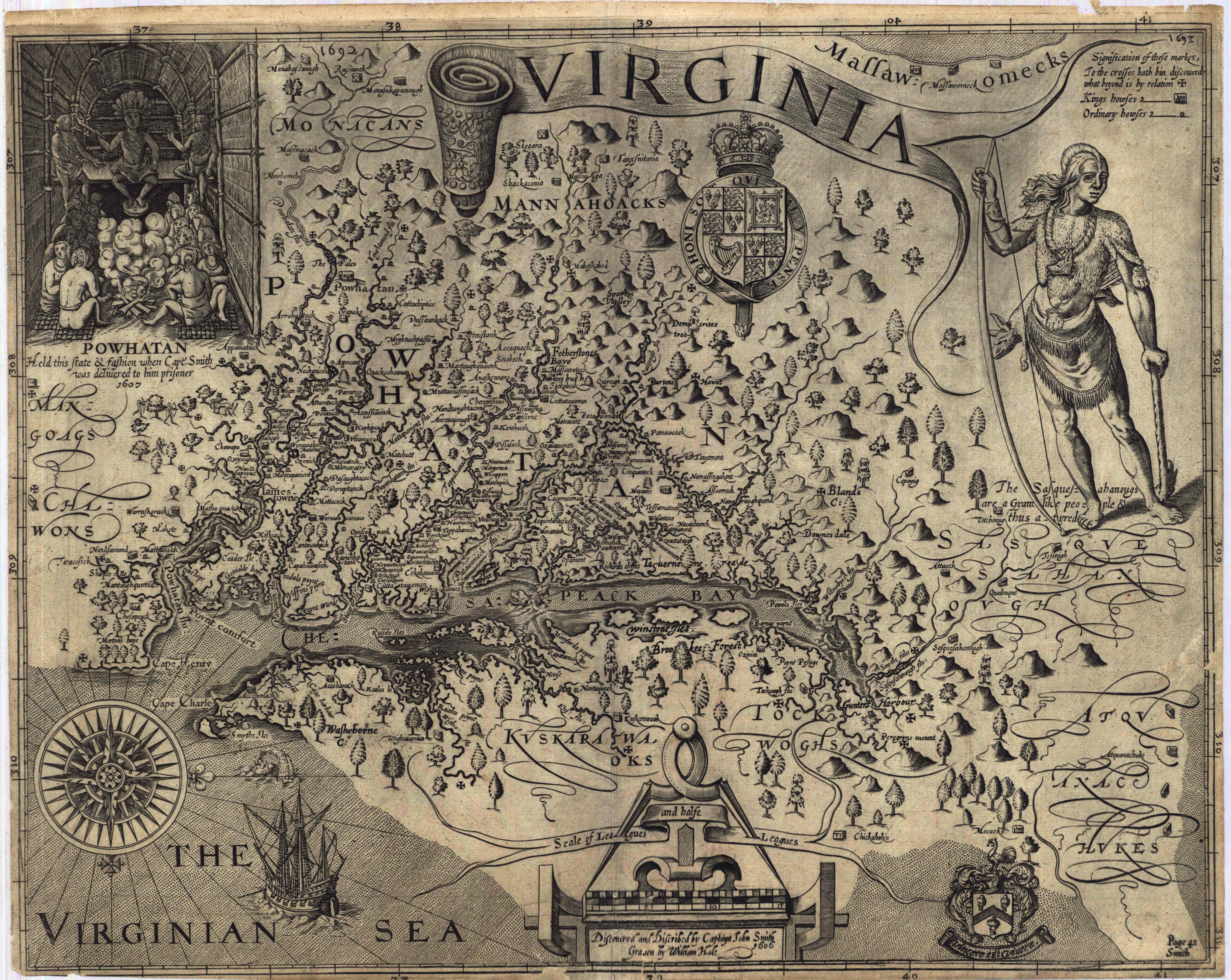
Captain John Smith's map, Virginia
Citation: MSA SC 1399-1-101
In the 1600s many Indigenous towns and
villages thrived in the Chesapeake
coastline and waterways when Captain
John Smith and his crew sailed into the
region to explore what for them was a
“new world.” Smith drew illustrations of
Powhatan (a paramount Chief based in
what is now Virginia) shown with his
people in a wigwam and another showing a
Susquehannock warrior. Smith recorded
locations of Native communities and
Indigenous place-names in a way that fit
with his colonizing ambitions,
preserving some and renaming others in
English. The Captain also did not
understand relationships between the
Peoples that he encountered and
perpetuated some misinformation. The
publication of this engraved map in 1612
heralds the destruction of Indigenous
cultures on the one hand, but it also
preserves important fragments about the
communities that predated the English
invasion.
|
The Plat of Indians Land on the Choptank River
Citation: S1219-1083-027
A surveyor drew this plat of 16,429
acres in Dorchester County to denote
what the English Colonists thought of as
land set aside for the Choptank Indians.
This fragmented plat is one page from a
Land Office Certificate of survey file
documenting land described as “Nanticoke
Mannor, Vienna Town, Nanticoke Indian
Lands.” A certificate of survey is an
official description of a plot of land.
The Land Office issued warrants of
survey to the county surveyor who then
generated certificates of survey as part
of the land patent process. This plat is
unpatented, meaning a land patent was
not issued.
|
| Back to Top |
April 1666 Treaty of Maryland with multiple Nations and Reparation
Citation: S977-2 (Pages 280-283)
Articles of Peace and Amity, dated 20
April 1666, between the Lord Baron of
Baltimore and the Province of Maryland
and the Pascattaway, Anacostanck, Doags,
Mikikiwomans, Manasquesend, Mattawomans,
Chingwawateick, Hangemaick, Portobackes,
Sacayo, Panyayo, and Choptico Nations,
regarding the Rules and Restrictions
concerning Colonial/Indigenous Relations
and Reparations to the Chingwawater and
Nangemaick Nations for Colonists'
Crimes. Signed by: Amehoick for the
Matchecomico and Sacayo, Choticke
Councellor of Chingwawateick and
Pangayo, Unawcawtanim for Mattawoman,
Necutahamon King of Nangemy, and
Mawnawzimo for Nangemy.
|
December 1669 Land and Trade Agreements between Maryland and multiple Indigenous Nations
Citation: S1071-5 (pages 304-305)
Declared on 15 December 1669 at the City
of St. Marys, that the Lands Allocated
to the Pascattaway, Annacostanck, Doags,
Mikikiwoman, Manasquesend, Mattawomans,
Chingwawateick, Nanjemauk, Portobacco,
Sacayo, Pangayo, and Chaptico Indians
belong explicitly to those Tribes, and
no Colonists may settle there; however,
Trade must be Maintained between the
English and the Eastern Shore
Indigenous.
|
Treaty between Maryland and the Assateague and Pocomoke Nations
Citation: S552-12 (page 408-412)
Articles of Peace and Amity, dated 22
October 1722, between the Province of
Maryland and Knosulin, alias Mr. Walker,
and Wassennge, alias Daniel, Chiefs of
the Assateague and Pocomoke Nations
respectively, with specific Demands for
Yearly Tribute for English Protections.
Signed by: Knosulin, King of the
Assateague Indians and Wassennge, King
of the Pocomoke Indians.
|
Treaty between Maryland and the Passayoncke Indians
Citation: S1071-5 (pages 117-119)
Articles of Peace and Amity, dated 19
September 1661, between the Province of
Maryland and Pinna, King of
Pickhattomitta, on behalf of the
Passayonke Nation in Response to Violent
Interactions between Indigenous Peoples
(Passayonke, Miniqua, or Sinigo) and
colonists. Signed by: Pinna.
|
Treaty between Maryland and the Piscattaway and Pamunckey Nations and Relocation of both Nations to Pomunckey
Citation: S1071-13 (pages 236-243)
Articles of Peace and Amity, dated 9
April 1700, between the Province of
Maryland and Oquotomaquah, the Emperor
of Piscattaway, and the Province of
Maryland and Izingoughsiowaugh, the
Queen of Pamunckey, with Specific
Demands for Yearly Tributes for English
Protections and the Relocation of both
Nations to Pomunckey.
|
Renewal of Peace Treaty with Sinnico and Pascattaway Nations
Citation: S1071-7 (pages 216-219)
Exchange of Gifts and a Renewal of Peace
between the Sinnico (called
Sachochinagheti) and Pascattaway Nations
and the English, dated 16 April 1685, in
Baltimore County.
|
Land Patent for Zaccaya and Pangaye's Manors
Citation: SM215-7
Specific Locations of Zaccaya and
Pangaye's Mannors along Wiccomocco River
and Portobacke Creek respectively, as
determined in Late April, 1667 for the
Possession of the Lord Proprietary.
|
Treaty between Maryland and the Sasquesahanogh Nation
Citation: S1071-5 (pages 62-63)
Articles of Peace and Friendship, dated
5 July 1652, between the Province of
Maryland and the Sasquesahanogh Nation
defining the Relationship between the
Two Parties, while also specifically
detailing English Land Claims to Land in
and around the Chessapeake Bay. Signed
by: Sawahegeh, Treasurer, and War
Captains and Councellors Aurotaurogh,
Scarhuhadih, Ruthcuhogah, and
Wathetdianeh.
|
June 1666 Treaty with the Sasquesahanogh Nation and Reparations
Citation: S1071-5 (pages 263-264)
Articles of Peace and Amity, dated 29
June 1666, between the Province of
Maryland and Wastahanda Hariguera and
Gosweinquerack qua, War Captains of the
Sasquesahanough Nation in Response to
the Deaths of Englishmen in Baltimore
County by one Wanahedana of the
Sasquesahanoughs; Demand for the
Deliverance of the Two Sons of the King
of Potomack to Major Samuell Goldsymth
as Prisoners as Part of Reparations.
Signed by Wastahanda Hariguera and
Gosweinquerack qua with Pictographic
Signatures.
|
Captain John Smith's map, Virginia
Citation: MSA SC 1399-1-101
In the 1600s many Indigenous towns and
villages thrived in the Chesapeake
coastline and waterways when Captain
John Smith and his crew sailed into the
region to explore what for them was a
“new world.” Smith drew illustrations of
Powhatan (a paramount Chief based in
what is now Virginia) shown with his
people in a wigwam and another showing a
Susquehannock warrior. Smith recorded
locations of Native communities and
Indigenous place-names in a way that fit
with his colonizing ambitions,
preserving some and renaming others in
English. The Captain also did not
understand relationships between the
Peoples that he encountered and
perpetuated some misinformation. The
publication of this engraved map in 1612
heralds the destruction of Indigenous
cultures on the one hand, but it also
preserves important fragments about the
communities that predated the English
invasion.
|
The Plat of Indians Land on the Choptank River
Citation: S1219-1083-027
A surveyor drew this plat of 16,429
acres in Dorchester County to denote
what the English Colonists thought of as
land set aside for the Choptank Indians.
This fragmented plat is one page from a
Land Office Certificate of survey file
documenting land described as “Nanticoke
Mannor, Vienna Town, Nanticoke Indian
Lands.” A certificate of survey is an
official description of a plot of land.
The Land Office issued warrants of
survey to the county surveyor who then
generated certificates of survey as part
of the land patent process. This plat is
unpatented, meaning a land patent was
not issued.
|
| Back to Top |
Image of 1652 Treaty between Maryland and Sasquesahanogh Nation - Page 1
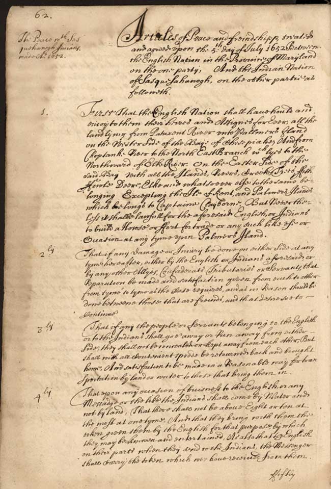
Image of 1652 Treaty between Maryland and Sasquesahanogh Nation - Page 2
Page 1 Treaty between Maryland and Passayoncke Indians
Page 2 Treaty between Maryland and Passayoncke Indians
Page 3 Treaty between Maryland and Passayoncke Indians
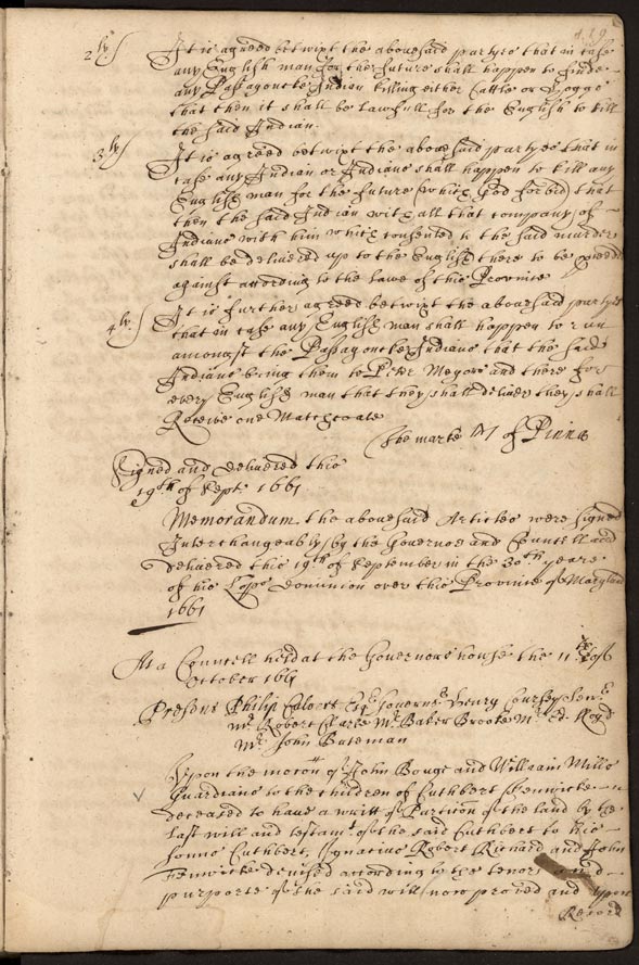
Image of June 1666 Treaty with the Sasquesahanogh Nation and Reparations
Page 1
Image of June 1666 Treaty with the Sasquesahanogh Nation and Reparations
Page 2
Land Patent for Zaccaya and Pangaye's Manors
December 1669 Land and Trade Agreements between Maryland and multiple Indigenous Nations
Page 1
December 1669 Land and Trade Agreements between Maryland and multiple Indigenous Nations
Page 2
April 1666 Treaty of Maryland with multiple Nations and Reparation - Item 1
April 1666 Treaty of Maryland with multiple Nations and Reparation - Item 2
April 1666 Treaty of Maryland with multiple Nations and Reparation - Item 3
April 1666 Treaty of Maryland with multiple Nations and Reparation - Item 4
Renewal of Peace Treaty with Sinnico and Pascattaway Nations - Item 1
Renewal of Peace Treaty with Sinnico and Pascattaway Nations - Item 2
Renewal of Peace Treaty with Sinnico and Pascattaway Nations - Item 3
Renewal of Peace Treaty with Sinnico and Pascattaway Nations - Item 4
Treaty between Maryland and the Piscattaway and Pamunckey Nations and Relocation of both Nations to Pomunckey - Item 1
Treaty between Maryland and the Piscattaway and Pamunckey Nations and Relocation of both Nations to Pomunckey - Item 2
Treaty between Maryland and the Piscattaway and Pamunckey Nations and Relocation of both Nations to Pomunckey - Item 3
Treaty between Maryland and the Piscattaway and Pamunckey Nations and Relocation of both Nations to Pomunckey - Item 4
Treaty between Maryland and the Piscattaway and Pamunckey Nations and Relocation of both Nations to Pomunckey - Item 5

Treaty between Maryland and the Piscattaway and Pamunckey Nations and Relocation of both Nations to Pomunckey - Item 6
Treaty between Maryland and the Piscattaway and Pamunckey Nations and Relocation of both Nations to Pomunckey - Item 7
Treaty between Maryland and the Piscattaway and Pamunckey Nations and Relocation of both Nations to Pomunckey - Item 8
Treaty between Maryland and the Assateague and Pocomoke Nations - Item 1
Treaty between Maryland and the Assateague and Pocomoke Nations - Item 2
Treaty between Maryland and the Assateague and Pocomoke Nations - Item 3
Treaty between Maryland and the Assateague and Pocomoke Nations - Item 4
Treaty between Maryland and the Assateague and Pocomoke Nations - Item 5
Captain John Smith's map, Virginia
The Plat of Indians Land on the Choptank River
© Copyright 2023 Maryland State Archives